Rand McNally
Rand Mcnally Folded Map: New York City Long Island Regional Map
Rand Mcnally Folded Map: New York City Long Island Regional Map
ISBN-13: 9780528025570
Precio habitual
$13.49
Precio habitual
Precio de oferta
$13.49
Precio unitario
/
por
Los gastos de envío se calculan en la pantalla de pago.
No se pudo cargar la disponibilidad de retiro
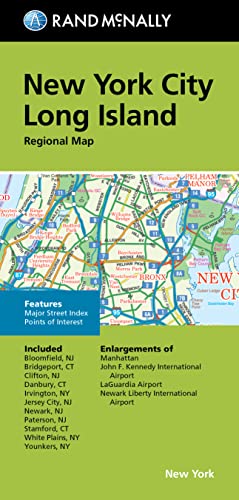
Rand McNally's folded map for New York City Long Island is a must-have for anyone traveling in and around this part of New York, offering unbeatable accuracy and reliability at a great price. Our trusted cartography shows all Interstate, U.S., state, and county highways, along with clearly indicated parks, points of interest, airports, county boundaries, and streets. The easy-to-use legend and detailed index make for quick and easy location of destinations. You'll see why Rand McNally folded maps have been the trusted standard for years. - Regularly updated. - Full-color maps. - Clearly labeled Interstate, U.S., state, and county highways. - Indications of parks, points of interest, airports, county boundaries, downtown & vicinity maps. - Easy-to-use legend. - Detailed & full street index. - Major Street index. - Enlargements of Manhattan, John F. Kennedy International Airport, LaGuardia Airport, Newark Liberty International Airport. - Convenient folded size. Coverage Area Communities Included: Bloomfield, NJ, Bridgeport, CT, Clifton, NJ, Irvington, NY, Jersey City, NJ, Newark, NJ, Paterson, NJ, Stamford, CT, White Plains, Younkers, NY. Product Details: Measures 9.5' x 4' and folds out to 40' x 28'.
- | Author: Rand Mcnally
- | Publisher: Rand McNally
- | Publication Date: Aug 12, 2022
- | Number of Pages: Not Available pages
- | Language: English
- | Binding: Map
- | ISBN-10: 0528025570
- | ISBN-13: 9780528025570
Share